
Walk an Alexandria Street Record
An Alexandria street directory search works best as a chain. Each stop answers a different question. USPS confirms the current mail form. The City Engineering map places the street against cross streets, neighborhood labels, and city limits. The Rapides Parish Assessor links a physical address to a parcel and record owner. The Recorder supplies the instruments behind that parcel. Historical directories, maps, and newspapers add dated address associations. Keep the source date with every result.
- Save the address exactly as received. Check its current delivery form with the USPS ZIP Code Lookup.
- Place the street on the Alexandria Engineering map. Note cross streets and the city-limit line.
- Search the physical address through the Rapides property portal. Save the parcel number, situs, mailing address, legal description, subdivision, and owner field.
- Use the owner and legal description in Rapides Parish Recorder records. Follow grantor, grantee, book and page, instrument, plat, and later transfers.
- Check the official voter address form and dated historical sources only when a person link is needed. State exactly what each source proves.
A parcel owner may get tax mail elsewhere. A person registered at an address may not own it. A historical entry proves an association in its publication year, not a present household. The street-by-street method works only when those roles remain distinct.
Search Alexandria Streets by Parcel
The Rapides Parish Assessor says its free records can be searched by name and address. Its official site links an interactive map and DataScout. Vendor guidance documents several search concepts, though required fields and exact partial-match behavior were not captured for Rapides Parish. Start broad enough to catch format differences, then preserve exact labels from the result.
| Alexandria field | Input | Caution |
|---|---|---|
| Owner or business | Name text | Person, estate, trust, and business roles differ. |
| Parcel or assessment number | Exact identifier | Keep the displayed format. |
| Street number, direction, name | Address fields | Do not add a unit unless offered. |
| Subdivision | Name or selection | Not the same as a neighborhood. |
| Property type | Category | Documented concepts include all, improved and vacant, residential, and commercial. |
| Transfer details | Date, price, grantee, deed | Confirm in the recorded instrument. |
| Mailing address | Separate address | Does not prove occupancy. |
The Rapides Parish Assessor is at 701 Murray Street, Suite 101, Alexandria, and lists weekday service from 8:00 a.m. to 4:00 p.m. Its phone is 318-448-8511. The counter is the fallback when a parcel number, map pin, or legal description cannot be reconciled online.
Alexandria Records Indexed by Address
No Alexandria address source does every job. The sets overlap enough to test one another. Property data provides a parcel anchor. Maps add geography. Recorded instruments explain legal transfers. Voter results may show registrations for one entered address. Directories and newspapers add historical snapshots. Permits require a defined request because no public current permit-history name search was found.
| Record source | Keeper | Street evidence | Access |
|---|---|---|---|
| Property record | Rapides Assessor | Parcel, owner, situs, mailing, legal description | Free online, phone, counter |
| Planning map | RAPC | Parcel and planning context | Public GIS page; confirm with Assessor |
| Conveyance and plat | Rapides Clerk | Parties, instrument, book/page, subdivision | RAPID, eClerks, physical record |
| Voter address result | Secretary of State | Registration matches at one address | ZIP, address, and city form |
| Permit file | City of Alexandria | Dated application or work record | Defined records request |
| Historical source | Libraries and archives | Dated name, business, map, or notice | Digital, shelf, or staff request |
The Louisiana voter address lookup requires a five-digit ZIP, address, and city. Apartment or lot is optional. It is not a street-wide roster, and protected fields remain withheld.
Note: Alexandria street records show recorded roles at set dates; they do not certify everyone present at an address today.
Decode Alexandria Address Terms
Street searches join systems that use different labels. Four terms keep the Alexandria street directory from producing false matches.
- Parcel
- A mapped unit of land identified by the Assessor. One address can involve more than one parcel.
- Situs address
- The physical property location, distinct from the address where tax or legal mail is sent.
- Plat
- A recorded map of lots, blocks, roads, and subdivision boundaries.
- Criss-cross directory
- A directory arranged by street and number. It is a dated historical source, not a current household list.
Legal descriptions can use lot and block, subdivision, section-township-range, metes and bounds, or a prior instrument. Preserve the wording. It can bridge an old address to a modern parcel when street numbers differ, but that link still needs a map, plat, or recorded reference.
Map Alexandria Streets and Limits
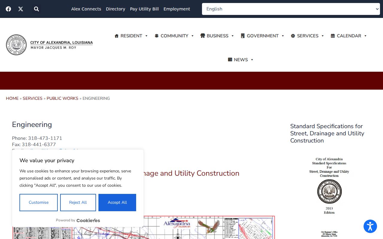
The Alexandria base map is the best official navigation source located for the city grid. Created by City Engineering in January 2016, it includes a street index, public places, neighborhood labels, and streets marked inside, outside, or moving in and out of city limits. It shows an approximate incorporated area of 28.88 square miles.
The map does not show parcel owners. Use it to settle orientation and jurisdiction before opening property records. A postal Alexandria line does not by itself place land inside the city. City records, parish records, and RAPC rules may send similar postal addresses to different custodians.
The successful City Engineering source provides the official map route.
Check Alexandria Street Map Layers
The Rapides Area Planning Commission GIS page says its map uses live in-house data and multiple datasets. It gives two clear cautions. Current parcel data should come from the Assessor, and its map is not an official FEMA flood map or insurance-rating source. The direct map URL, exact search labels, parcel controls, and export tools were not exposed in the reviewed text.
Use GIS for context, not as the final record. Save the layer name and map date if the live application appears. Confirm parcel number, owner, situs, and legal description through the Assessor, then test a boundary or right-of-way against a plat or deed. Do not claim a buffer, street-browse, or parcel-click feature unless the current interface displays it.
Follow Alexandria Deeds Along Streets
After identifying the parcel, a deed chain turns the street number into ownership history. Search the current owner as a grantee. Capture instrument number, date, grantor, grantee, type, legal description, and book/page. Follow the prior deed reference or seller's earlier purchase. Later conveyances, donations, partitions, succession judgments, and cancellations can alter the result.
RAPID conveyance index and images begin in January 1984, with selected older recording material back to January 1865. Mortgage index and images begin in January 1984. Plats are indexed from that date without images in the published coverage. When an index lacks an image or conflicts with a book, the physical Clerk record controls.
The Clerk also participates in eClerksLA. The Recorder counter and record request remain vital for old or unindexed instruments. A grantee is not always the current owner, and an owner is not automatically an occupant.
Resolve Old Alexandria Street Lines
No official Alexandria street-renumbering year or ordinance was located. When an old number has no current match, search its exact period spelling, suffix variants, nearby entries, and cross streets. Use the right historic district map, plat, or deed description. Never invent a modern number because two street names look alike.
The Downtown nomination frames older research with 2nd, Jackson, Beauregard, 4th, 5th, 6th, Murray, Washington, and Lee streets. AHPC maps distinguish Original Town, West End, Garden District, and later areas. Jackson Street appears in both West End and Garden District context, so verify the boundary.
For past household entries, the Alexandria city directory collections detail year runs and publishers. Keep that shelf research distinct from current street records.
Date Alexandria Street Records
City notices can date street conditions without naming residents. Alexandria listed 2026 water notices tied to Whitefield Boulevard and Lee Street. Council videos and minutes may explain projects, zoning, or public discussion. DOTD District 8 posts add state road context. Each proves an event or agency action, not a household.
Permits work the same way. Alexandria publishes permit forms, payment information, and reports, but no public address-history index was located. Send a narrow request through the City public-records route with the address, record type, and date range. Production fees and exemptions may apply.
Note: Keep the notice date, agency, street segment, and record type with every Alexandria infrastructure or permit finding.
Limits of Alexandria Street Directories
An Alexandria street directory cannot identify everyone on a block. Property records may name an estate, trust, business, or owner elsewhere. Mailing addresses do not establish occupancy. Voter data omits protected fields and may change. No public utility customer-history index was located. Maps show land and boundaries, not household members.
Several ordinary records also describe roles that are easy to misread. A permit may name an applicant or contractor. A deed may name a trustee, agent, donor, heir, or business. An address-assignment form describes a planned structure and nearby roads, not a move-in date. A historic district label says something about mapped geography, but it does not prove that a building is listed or that a named person lived there. Each claim should keep the field label used by its source.
Use a narrow purpose such as family history, a deed question, property curiosity, or confirming a seller's recorded interest. Confidentiality rules may shield an address. Missing data can reflect protection, a source cutoff, an unindexed book, or a mismatch. It does not prove that no person or record exists. When an online search fails, contact the named custodian with the parcel, street form, date range, and precise record type. Ask for a written response if the record is unavailable.
Lawful use. Use Alexandria address records only for lawful personal research. Never use them to stalk, harass, intimidate, or harm anyone.